
Switzerland is a country celebrated for its breathtaking scenery, encompassing majestic mountains, pristine lakes, and an extensive network of stunning rivers. These rivers, fed by the melting snow from the Swiss Alps, meander through valleys and make up approximately 4% of the nation’s land area.
They offer diverse experiences, from tranquil, multi-purpose trails frequented by cyclists, joggers, and families, to more untamed, secluded footpaths that reveal the rivers’ captivating beauty. Discover some of the most remarkable Swiss Rivers to include in your itinerary for an unforgettable experience, as Switzerland Rivers presents the ideal destination for both serene winter vacations and invigorating summer getaways.
The 10 Longest Rivers In Switzerland
| Rhine | 375 km |
| Aare | 295 km |
| Rhône | 264 km |
| Reuss | 158 km |
| Linth / Limmat | 140 km |
| Inn | 104 km |
| Saane / La Sarine | 128 km |
| Thur | 125 km |
| Ticino | 91 km |
| Hinterrhein | 57 km |
The Rhine
The Rhine is Switzerland’s longest river, draining 80% of the country’s surface through its powerful tributaries. The Rhine has two headwaters in Graubünden, and its source is Lake Toma at the Oberalp Pass. The river flows through the stunning Rhine Gorge near Illanz and past Graubünden’s capital, Chur, before turning northward towards Lake Constance.

With a rich historical background as a leading trade and transport route in Europe, the Rhine is also the second-longest river in Central Europe. Of its total 1230 km length, 375 km flows through Switzerland, with tributaries extending through Germany and the Netherlands before emptying into the North Sea.
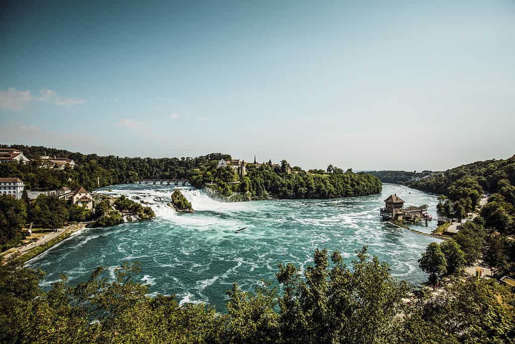
At Neuhausen, the Rhine plunges into the depths at the Rhine Falls, where 700 cubic meters of water cascade downwards per second during summer. Daredevils can embark on boats that venture close to the roaring waters. The Rhine mainly forms the border with Germany and, near Koblenz, the Aare’s confluence more than doubles the water mass. Basel is the last Swiss city through which the river flows. It continues to wind its way through Germany.
The Aare
The Aare, the longest wholly Swiss river at 295 km, originates from the Oberaar glacier in the eastern Bernese Alps and is a tributary of the High Rhine.

You might also like the following article:
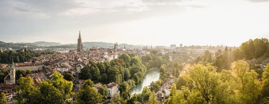
The Aare carves through a deep ravine near Meiringen before flowing into Lakes Brienz and Thun, where scheduled passenger boats, including a historic paddlewheel steamer, operate. The Aare then flows past Bern, forming the famous “Aare loop” around the the UNESCO World Heritage Site old town.
After passing Lake Biel, passenger vessels operate on the river section from Biel to Solothurn in the summer. The Aare continues towards its confluence, flowing past Olten, Aarau, and Brugg before merging with the Reuss and Limmat rivers and eventually opening into the Rhine after 291 km.
In spring and summer, locals and visitors enjoy swimming, sunbathing, and various water sports like surfing, rafting, stand-up paddling, and tubing along the Aare’s beautiful turquoise waters. The public, open-air river swimming pools of Marzili and Lorraine in Bern are popular spots for relaxation while admiring the charming river and city views.
Reuss
The Reuss River, Central Switzerland’s iconic waterway, starts in the Gotthard region, specifically in the Swiss Alps, in the same area as the Rhine and Rhone, known as the Gotthard massif. Flowing entirely within Swiss territory, the river covers 160 kilometers, passing through Lake Lucerne before joining the Aare River in the town of Gebenstorf.
The Reuss forms from smaller rivers near Gotthard and Furka Passes and flows through the steep Schöllenen Gorge. It shares the valley with the Gotthard transit route before entering Lake Uri. Cruising on a Belle Epoque paddle steamer across Lake Lucerne offers stunning views of mountains like Rigi, Pilatus, and Stanserhorn.
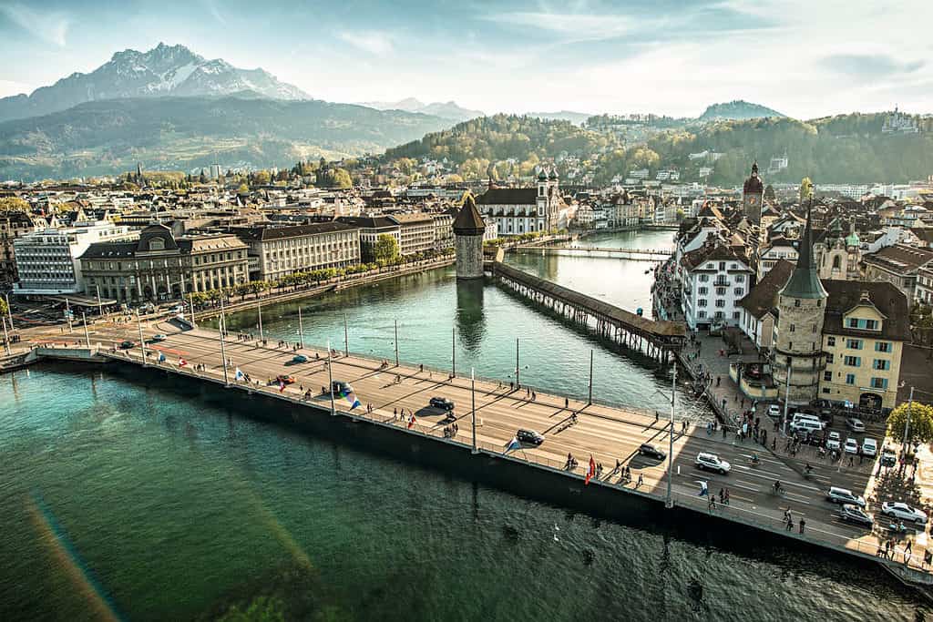
In Lucerne, the Reuss serves as the region’s economic and cultural hub, attracting visitors worldwide for shopping. Flowing out of Lake Lucerne at the city of Lucerne, the river continues its journey, becoming a canoe paradise near its end. Canoe enthusiasts can start their journey at the town of Bremgarten and enjoy the magical scenery along the way, renting canoes and joining paddle tours with ease. Paddling tours usually end at Gebenstorf, just before the river joins the Aare, and provide a great way to experience the stunning Swiss landscapes. The Reuss River is absolutely beautiful and one that should not be missed.
The Rhone
The Rhone, Western Switzerland’s main river, originates from the Rhône glacier in the Swiss Alps, situated in the canton of Valais. As one of Switzerland’s longest rivers, and the second-longest non-tributary, it spans 264 km within the country before entering France and eventually reaching the Mediterranean Sea.
The Pfyn Forest near Leuk marks the Swiss-French language border. The Rhone, now canalized over long stretches, is surrounded by vast vineyards and orchards. The national skating route follows the Rhone after Sierre, ending in Vevey, while cyclists trace its path on the Rhone Route up to Geneva.
After passing Sion, the Rhone turns north at Martigny. In its final stretch through the Chablais region, it’s bordered by Canton Vaud on the right and Canton Valais on the left. A Lake Geneva steamer cruise continues the journey, sailing through the Lavaux vineyards (UNESCO World Heritage) and by Montreux, Vevey, and Lausanne, until reaching Geneva, home to many international organizations.

A prime location to admire the Rhone is where it exits Lake Geneva in the city of Geneva. Here, the Rhone converges with the Arve River, transforming from a deep blue to a vibrant turquoise hue. The picturesque surroundings make a riverside walk an essential activity.
The Rhone exits Switzerland after 264 kilometers, heading towards France and the Mediterranean.
Linth & Limmat
The Linth & Limmat River, an Aare tributary, starts in the mountain town of Linthal and flows into Lake Zurich and stretches 140 km when connected.
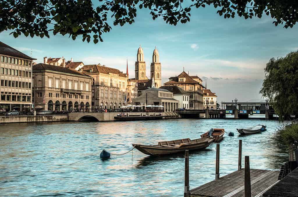
The Limmat River begins as it flows out of Lake Zurich, running right through the heart of Zurich’s Old Town. It flows for only 35 km, passing the charming old town of Baden, before joining the Aare river downstream. The river is very beautiful and a major attraction for the city.
It played a big role in the area’s textile industry, and now, hydroelectric power stations use it to generate electricity.
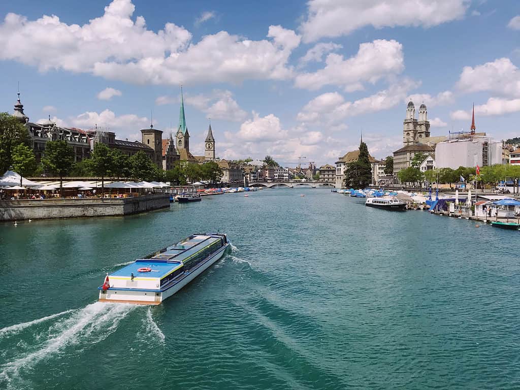
While in Zurich, consider embarking on a boat tour along the river, which costs approximately CHF 4.40 for adults, offering scenic views of the Old Town. Additionally, the city boasts around 40 outdoor pools situated on the river and Lake Zurich, providing refreshing swimming opportunities during warm summer days.
The Inn
The River Inn starts in the high mountain valley of Engadin in Graubünden. It flows 90 km eastwards past the popular St. Moritz in Upper Engadin, continues through Lower Engadin and heads northeast into Germany and Austria, continuing for 518 km until it joins the Danube.
The small river, which begins north of Maloja Pass, flows into Lake Sils and Lake Silvaplana, attracting sailors and (kite) surfers. In winter, cross-country skiers use the river’s trails, while hikers explore them in summer. Cyclists enjoy the 500-kilometer Inn cycle trail from Majola. Villages with traditional Engadin houses line the river, including Zernez, the Swiss National Park’s gateway.

As Lower Engadin narrows, the river, road, and Rhaetian Railway come close together. The Inn becomes popular for rafting, offering varying levels of difficulty. Scenic villages like Guarda and Ardez are nearby. Scuol, the Lower Engadin capital, is near the Austrian border, where the Inn leaves Switzerland.
The Inn is unique as it’s the only Swiss river that flows into the Black Sea, and it’s a crucial waterway for Germany and Austria. By the time it reaches Passau in Bavaria, it becomes the Danube’s (Europe’s longest river) largest tributary.
Thur
The Thur River starts in Toggenburg valley and flows through parts of St. Gallen, Thurgau, and Zürich. It’s a major Eastern Swiss river and a Rhine tributary, stretching 125 km. Since it has no reservoir, it’s prone to flooding, so there are many flood protection projects.
In the upper Toggenburg, two rivers merge to form the Thur. Before this, the Säntisthur creates the Thur Waterfalls, which you can easily explore with bridges and tunnels. The river flows through a beautiful landscape up to the historic town of Wil.
The baroque Old Town of Bischofszell is near where the rivers Thur and Sitter meet. The Thur flows past forests, orchards, vineyards, and charming villages, heading towards Frauenfeld, with its medieval castle.
Before joining the Rhine, the river forms the Thur Meadows, Central Switzerland’s largest wetlands. The river’s natural path here creates habitats for rare plants and animals, making the Thur a beautiful and important river.
The Ticino River
Originating in the Gotthard Massif, the Ticino flows nearly 250 km before merging with the Po River in northern Italy. It passes through Bedretto Valley, Leventina, Magadino Plain, and Lago Maggiore.

Val Bedretto and Leventina Valley are popular for panoramic hiking tours. The Ticino Biking Trail follows the river, while wild water kayakers and rafters enjoy challenging sections. Notable sights along the banks include Giornico’s Romanesque church of San Nicolao and Bellinzona’s three UNESCO World Heritage castles.
Majestic valleys like Maggia and Verzasca attract visitors, as does Ticino’s highest waterfall, the Santa Petronilla Waterfalls in Biasca.
After Bellinzona, the Ticino passes the lively towns of Locarno and Ascona and finally enters Lago Maggiore. Over 200 species of migrating birds rest in the wetlands where the Ticino River enters Lago Maggiore, known as Bolle di Magadino.

After leaving Switzerland, the river flows into Italy, descending the Alps and entering Lake Maggiore. It then exits Lake Maggiore and continues for hundreds of kilometers before joining the River Po, which eventually empties into the Adriatic Sea.
Saane River / La Sarine
The Saane River or La Sarine, though not one of Switzerland’s largest, offers a range of experiences and adventure opportunities. It stretches 128 km from the Swiss Alps and eventually joins the Aare River. The river, sometimes called the “Rösti ditch,” serves as a dividing line between German-speaking and French-speaking parts of Switzerland.
Starting at the Sanetschhorn above Gsteig in Valais, the river is called Sarine. It flows past Gstaad, through Pays d’Enhaut, and reaches Freiburg, where it becomes the Saane River again.

River rafting and canoeing are popular on the Saane, especially in the 15-kilometer stretch between Gstaad and Château-d’Oex. Here, rapids and waves provide excitement for adventurers, while the section from Lake Schiffenen to the Saane estuary is calmer.
The Saane River features impressive bridge architecture, including a hidden covered wooden bridge between Montbovon and Lessoc, Pont du Châtelet near Gruyères, Broc’s old stone bridge, and the wooden Pont de Berne in Freiburg. The Grandfey railroad bridge is another highlight.
The Saane also flows near Gruyeres and through the heart of Fribourg, offering a fantastic spot for residents and visitors to relax and enjoy the water during the warmer season.
Doubs River
The Doubs River displays a variety of scenes, from picturesque gorges and raging torrents to romantic lakes and idyllic riverbanks that separate France and Switzerland. A boat trip from Les Brenets to Maison Monsieur holds more surprises, including a visit to the underground mills at Col-des-Rochers, located near Le Locle.

FAQ Rivers Of Switzerland
What is Switzerland’s longest river?
The Rhine, at 375 km long, is Switzerland’s longest river. It originates in the Swiss Alps and flows to the German border, where it continues alongside Switzerland’s northern neighbor.
Which rivers flow through Switzerland?
Several major rivers flow through Switzerland, including the Rhine, Rhone, and Inn. These rivers begin in the Alps and traverse Europe, ultimately reaching the sea. The Rhine flows from the Alps to the North Sea in the Netherlands, the Rhone passes through Lake Geneva and France before reaching the Mediterranean, and the Inn River joins the Danube, eventually emptying into the Black Sea.
How many rivers are in Switzerland?
Switzerland has over 50 rivers, with a combined length exceeding 61,000 km. Many of these rivers are tributaries of larger rivers like the Rhine and Rhone or feed into other major rivers.
What is the longest river entirely in Switzerland?
The Aare River, with a length of 295 km, is the longest river entirely in Switzerland.
Why are Swiss rivers green?
Swiss rivers have a beautiful green-turquoise color due to their origins in the Alps, often from glaciers like the Rhône glacier. Glacial waters are rich in minerals, which give the rivers and lakes their distinctive color. These minerals dissolve and sink slowly, remaining suspended in the river’s flow and reflecting light to create a stunning color.
What is a 3-letter Swiss river?
A three-letter Swiss river is the Inn River.
Which river flows through Lucerne?
The Reuss River flows through Lucerne.